
- Winter weight boots, a torch and extra warm clothing.
Places to Visit
Walking really is the best way to see Northumberland, whether it be along the unspoiled coast, towns and villages or in the magnificent Northumberland National Park. There are so many choices available within a short distance from Welcome Hjem Log Cabin at Felmoor Park.
Take a relaxing stroll to walk off that tasty pub lunch or stride out on a long-distance moorland trail across Northumberland National Park – either way get ready for wide skies, dramatic views and a good dose of rich history, as there are more than 900 km (600 miles) of waymarked footpaths and bridleways to choose from.
Here are some of our recommendations of places to visit (in no order of preference):

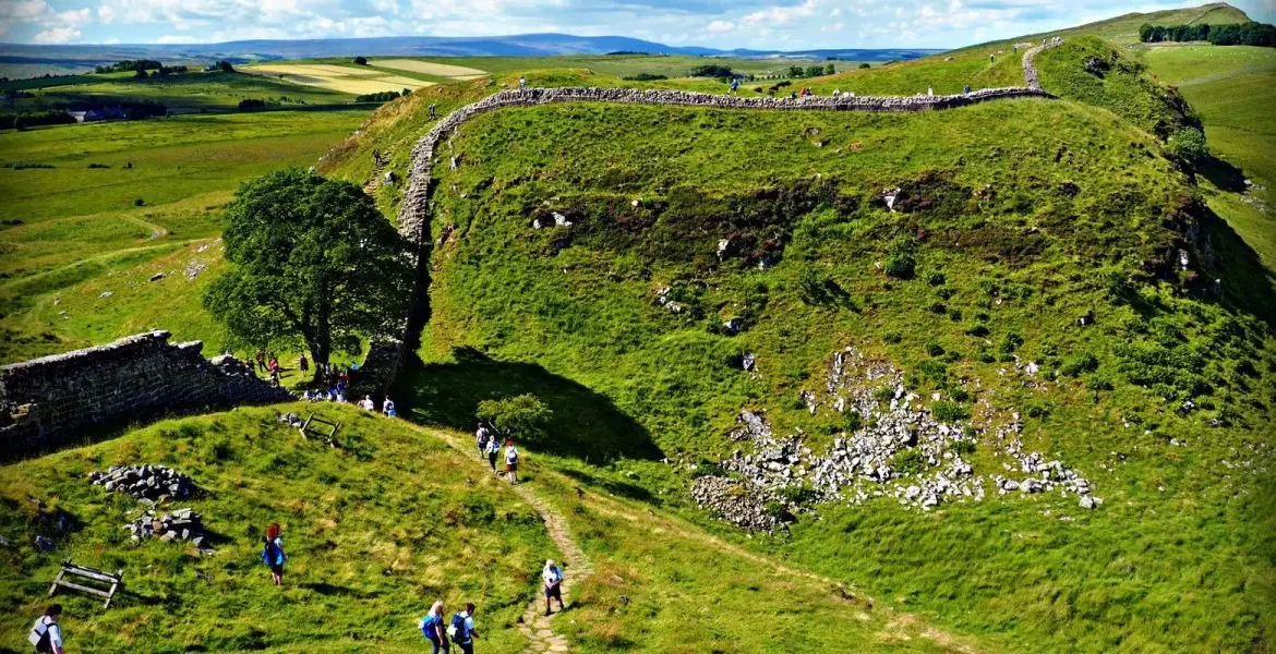
Sycamore Gap
The Sycamore Gap tree is probably one of the most photographed in the country. It stands in a dramatic dip in Hadrian’s Wall in the Northumberland National Park. In late 2016 it took the crown for English Tree of the Year in the Woodland Trust’s awards. We never knew such an award existed aswell.
The Roman Milecastle 39 is just to its left. It’s known as Castle Nick, as it sits in a nick in the hillside.
The site was excavated between 1908 and 1911 and re-excavated between 1982 and 1987. In the south-east corner was a stone oven and the south-west corner a rectangular building with a sunken floor associated with Roman finds. The milecastle appears to have been occupied until the late 4th century. In the 18th century, a possible milking house was built in the west corner.
The circular wall nearby protects a small replacement sycamore sapling from the local sheep, who would otherwise nibble on it. Sycamore Gap is looked after by both Northumberland National Park and the National Trust.
Getting there
Car:
You can see the tree from the nearby Military Road (B6318). To get there from the A1, take the A69, then Park Lane, turning onto Military Road at the Once Brewed junction. Sycamore Gap lies just to the east of Milecastle 39.
Bus:
The Hadrian’s Wall bus stops at Steel Rigg Car Park. For details, click here.
On foot:
A 15-minute walk from either Steel Rigg car park or the Once Brewed car park.
what 3 words /// acting.gold.cools
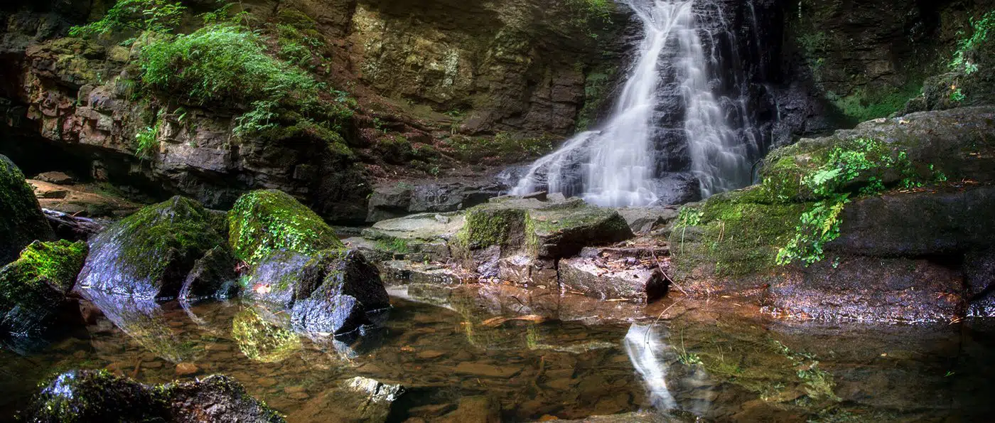
Hareshaw Linn
Cross six bridges to see a spectacular waterfall set in fantastic ancient woodland.
Visit Hareshaw Linn and take a magical walk through an ancient woodland, crossing no less than six bridges to reach a beautiful nine-metre high waterfall.
This Site of Special Scientific Interest (SSSI) is designated for its rare ferns and lichen. More than 300 different types of mosses, liverworts and lichen can be found at Hareshaw Linn.
The oak, hazel, elm and ash trees that grow here are great for wildlife. Keep a look out for red squirrels, great spotted woodpeckers, redstarts, dippers, badgers and Daubenton’s bats.
This area was the site of an ironworks established by Messrs Bigge and Partners in 1833.
There were two blast furnaces, 70 coke ovens, 24 large roasting kilns for calcining the iron ore, a range of coal stores, a blacksmiths shop, wagon shed, stables and stores. The ironworks were in continuous production until 1848. Ten years later the plant was auctioned and many of the buildings demolished. You can still see the dam that supplied water to power the iron works and mounds formed from leftover ash and stone.
Getting there
By car
From the A1, take the A69 and A68 to Bellingham, then look for the Hareshaw Linn signposts.
Walk overview
Walk difficulty : Moderate
Walks for people with country walking experience and a good level of fitness. May include some steep paths and open country. Walking boots and warm, waterproof clothing are essential.
Walk distance 3 miles / 4.8km
Walk duration 2 hours
Location North Tyne & Redesdale
Recommended OS Map O.S. Explorer OL42
Accessible No
Accessible: Walks which are generally flat and free from barriers. Accessible means different thing to different people, you can find more information in the walk description.
Dog friendly Yes
Dog friendly walks have no stiles along the route. However, you may encounter livestock. Please remember to keep dogs on a lead and under effective control when walking near livestock. Your dog might be extremely well behaved and friendly, but remember that farm animals won’t know that.
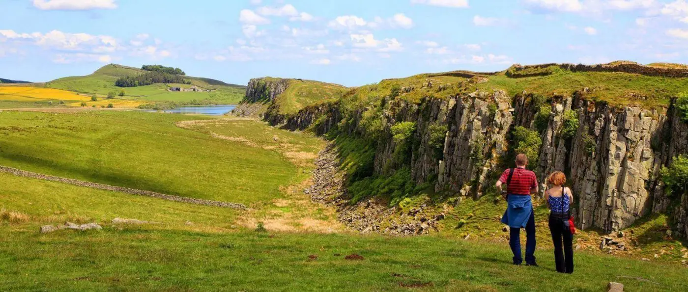
Steel Rigg / Crag Lough
Take a trip to Steel Rigg and treat yourself to some of the best viewpoints on Hadrian’s Wall.
Just a short walk from Steel Rigg Car Park you can see the Wall snaking up and along the crags, with the lake of Crag Lough in the distance.
Crag Lough was formed by glaciers in the last Ice Age and is one of the four Roman Wall Loughs. The other three are Broomlee, Greenlee and Halleypike.
Please note: Swimming is not permitted at Greenlee. Hidden hazards and extreme low water temperatures can be fatal. Please be responsible and consider your safety and the safety of those around you.
Getting there
By Car:
From the West
Follow the B6318 (Military Road) from Greenhead to the cross-roads with The Sill: National Landscape Discovery Centre. Turn left signposted ‘Steel Rigg’.
From the East
Follow the B6318 (Military Road) west to the cross-roads with The Sill: National Landscape Discovery Centre. Turn right signposted ‘Steel Rigg’.
Bus
The Hadrian’s Wall bus AD122 stops at The Sill: National Landscape Discovery Centre on the B6318 (Military Road). Walk up the narrow road signed ‘Steel Rigg’ to start the walk. Visit the Go NorthEast website for timetable information.
what 3 words /// blockage.deny.relax
Before your walk
Is the Walk suitable for you? Check the Walk Grade description and choose one suitable for everyone who is going.
For Self-Guided Walks, it is important for you to choose a walk suitable for everyone who is going. Think about options if the weather worsens. Don’t be over ambitious! Allow one hour for every 2.5 miles (4km) and add one hour for every 1,500 ft (500m) of ascent, with extra time for stops for rest and food.
Know how to use a map and compass. GPS or mobile phones aren’t enough as they can be lost or run out of power. Check out the weather forecast. Remember that fell top conditions can be far more severe than in the valleys.
Leave clear details of your intended route and estimated time of return. Know basic first aid and how to call for help in an emergency.
You can also find ‘guided walks’ our volunteers will guide you along the route and assess weather conditions and any other factors which could affect the Walk.
CLOTHING
Comfortable clothing/layers
- Waterproof/windproof outer jacket
- Boots with good sole pattern – trainers aren’t suitable as they can slip and don’t support your ankle
- Hat and gloves
- Spare warm clothing
When you’re resting, you may need more layers than when you’re on the move. Several thin layers give good insulation and can be adjusted for different terrain and weather conditions.
EQUIPMENT
- Comfortable daysack
- Food and water and a warm drink
- Some extra energy-giving food and emergency rations
- Large polybag or survival bag
- Whistle and torch
- First aid kit
- Map and compass
PLUS IN WINTER….
- Know and plan for the number of daylight hours.
- Check sunset times.Know the length of the walk.If walking at high altitudes: know how to use your ice axe and cramponsAvoid gullies after fresh snow